Getting around Genoa: Info and Tips
Quick Guide to Getting Around the City


Getting Around Genoa may seem complicated at first glance, but by understanding the main means of transportation, the city areas, and the connections between the port, downtown, and suburbs, getting around becomes simple and efficient, allowing you to fully enjoy all the beauty and experiences this city has to offer.
Overview
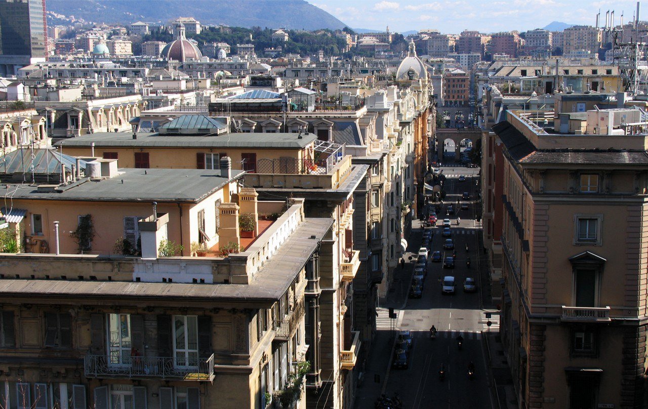
Getting around Genoa requires a bit of planning due to the city’s layout, which combines a dense, hilly historic center with modern neighborhoods and suburban areas. The presence of inclines, narrow alleys, and a road network that is not always straightforward makes it important to know the main available transportation options and the areas to reach.
In the historic center and along the carruggi (narrow, winding alleys typical of Ligurian historic centers, such as those in Genoa), walking often remains the most practical solution: the distances between main attractions, such as Porto Antico, Via Garibaldi, and Piazza De Ferrari, are short, and walking allows you to fully appreciate the urban structure and architectural details.
To reach neighborhoods outside the center or ascend to the hilly areas, Genoa offers a network of public transportation including buses, metro, and funiculars. These effectively connect the center, port, train stations, and residential areas, making movement easier even on busy days.
Using a private car is generally not recommended in the historic center, where narrow streets, heavy traffic, and the presence of ZTL zones and pedestrian areas limit circulation. Checking permits and available parking is essential to avoid fines or wasted time.
For first-time visitors to Genoa, a guided walking tour or a panoramic harbor tour can be very useful to understand the city’s layout, navigate alleys and inclines, and acquire practical reference points for later trips (see more info 🔗).
In recent years, alternative mobility options, such as shared bicycles and electric scooters, have also grown, mainly usable along the coast, promenades, and some flat streets. However, use should be carefully evaluated in hilly or narrow, busy areas.
Additionally, Genoa has some urban maritime lines that connect the port, coastal neighborhoods, and nearby locations, representing a scenic and convenient alternative to avoid city traffic.
Getting There
Genoa is well connected both nationally and internationally, thanks to a complex network of air, rail, road, and maritime links. Its strategic position on the Ligurian Sea makes it easily reachable for tourism, business, or as a starting point for the Riviera and main destinations in Northern Italy.
By plane
The Genoa Cristoforo Colombo Airport (see more info 🔗) is the city’s main airport and offers national and international connections, including low-cost flights. From the airport, the city center and main train stations can be reached by bus, taxi, transfer services, or rental car, with travel times averaging 15–30 minutes depending on the destination.
✅ To search or book flights from/to Genoa, you can check Booking.com Flights.
By train
Genoa Piazza Principe and Genoa Brignole are the city’s two main train stations, connected to major Italian cities via high-speed, Intercity, and regional trains. They allow easy access to the historic center, the port, and city districts thanks to the metro, bus network, and pedestrian connections.
✅ You can check routes, schedules, prices, and buy tickets with Trainline.
By car
Genoa is connected to the national highway network via the A10, A12, and A7 motorways. Drivers should consider the hilly layout of the city, urban traffic, and the presence of ZTL zones and pedestrian areas in the historic center. It is recommended to use park-and-ride facilities, private garages, or structures near main access roads.
✅ For car rentals, you can check Booking.com Cars.
By bus
Genoa is connected to numerous Italian and European cities via long-distance buses, with main stops near train stations and major urban hubs. Connections are well integrated with the local public transport network, facilitating travel to the historic center and port.
✅ You can check routes, schedules, and buy tickets with Trainline.
By taxi or private transfer
Taxis and private transfer services allow direct and comfortable access to Genoa from the airport, train stations, or nearby locations. Travel times vary depending on traffic and final destination, making this a convenient solution for travelers with luggage or who prefer door-to-door transport.
By ship
The Port of Genoa (see more info 🔗) is one of the main ports in the Mediterranean and an important maritime gateway to the city. The port is directly connected to the historic center and train stations via public transport, taxis, and pedestrian paths, making arrival particularly convenient for those traveling by ferry or cruise ship.
✅ You can check schedules, companies, and maritime connections with DirectFerries.
Getting Around on Foot
Walking is one of the best ways to explore Genoa, especially within the historic center, where many attractions, museums, and points of interest are located close to each other. Walking allows you to immerse yourself in the carruggi, discover hidden corners, and experience the authentic soul of the city.
Historic center and carruggi
The historic center of Genoa is perfect to explore on foot: areas such as Via Garibaldi, Piazza De Ferrari, Porto Antico, San Lorenzo Cathedral, and the Molo district are easily reachable with short walks. Narrow alleys and small squares make moving around surprisingly fast.
Distances and travel times
Many trips in the center take little time: from Piazza De Ferrari to Porto Antico is about 10 minutes on foot, while from Via Garibaldi to San Lorenzo Cathedral it takes less than 5 minutes. Longer routes, such as from the center to Belvedere Castelletto, require more time or the use of public elevators and funiculars.
Hills and slopes
Genoa is a very hilly city: many streets have steep inclines, staircases, and significant elevation changes. It is important to consider the terrain and plan routes, possibly combining walking with public elevators and funiculars.
Road surface and comfort
The road surface in the historic center is often uneven, with cobblestones, ancient pavements, and steps. Therefore, it is strongly recommended to wear comfortable and non-slip shoes, especially if planning long walks.
Traffic and safety
Vehicle traffic in the historic center is limited, but it is still necessary to watch out for scooters, service vehicles, and bicycles. Genoa is generally safe to explore on foot, but as in any large city, it is advisable to remain attentive in crowded areas and during evening hours.
Urban experience
Walking through Genoa means living an intense and authentic urban experience: medieval alleys, historic buildings, shops, sea views, and sudden panoramic openings make every journey part of the discovery, turning the route itself into a continuous exploration.
Public Transport
Public transport in Genoa allows you to move between the historic center, residential neighborhoods, hilly areas, and the port area, covering a long and complex city. The public transport system consists of metro, buses, funiculars, elevators, and urban railway services, providing solutions suitable for both short and more complex trips.
Metro
The Genoa metro has a single line connecting the Brin area to Brignole, crossing the city center and stopping at strategic points such as Darsena, San Giorgio, and De Ferrari. Although short, it is very useful for moving quickly between the port, historic center, and railway stations.
Urban buses
The AMT bus network is extensive and well-connected, with numerous lines linking the historic center, hilly neighborhoods, residential areas, and suburbs. Buses are essential for getting around a city with a complex layout, although they can be affected by traffic during peak hours.
Funiculars and elevators
A distinctive feature of Genoa’s public transport is the presence of funiculars and public elevators, used to overcome the steep differences in elevation between the center and hilly areas. Connections to Castelletto, Righi, or Montegalletto are integral to the urban network and also offer a panoramic experience.
Urban and suburban trains
Genoa also has urban and suburban railway services connecting the center with coastal neighborhoods and towns along the Riviera. Genova Piazza Principe and Genova Brignole stations serve as main hubs for quick east-west travel.
Taxis
Taxis are available at the airport, railway stations, the port, and main city squares. They offer a convenient solution for direct trips, nighttime travel, or journeys with luggage, especially to hilly areas less served by public transport.
Tickets and passes
The fare system offers single tickets, daily tickets, and passes valid on buses, metro, funiculars, and elevators. Integrated solutions are particularly convenient for longer stays or frequent public transport users. For up-to-date information on fares, schedules, and routes, it is recommended to consult the official AMT website.
When to use public transport
Public transport is especially useful for reaching hilly neighborhoods, suburban areas, railway stations, the port, and for covering medium-long distances. In the historic center, however, walking often remains the most practical and efficient option.
Getting Around by Car
Getting around Genoa by car can be useful for reaching some hilly areas, the western and eastern districts of the city, or nearby destinations. However, in the historic center and the most frequented areas, the urban layout, traffic, and circulation restrictions often make driving less practical than using public transport.
Limited Traffic Zones (ZTL)
Genoa has several active Limited Traffic Zones (ZTL), mainly in the historic center, such as the Porto Antico, Caricamento, and the inner alley areas. Access points are electronically monitored and entry is allowed only for residents and authorized vehicles. Checking activation times is essential to avoid fines.
Historic center and road layout
The historic center of Genoa is one of the largest in Europe and is characterized by narrow streets, one-way roads, and large pedestrian areas. Driving inside the narrow alleys is not recommended; it is better to park outside and continue on foot or by bus and metro.
Traffic and peak hours
Traffic in Genoa can be heavy during peak hours, especially along the main coastal routes and the connections between the city center and the hilly districts. Highway access points and port areas may also experience congestion. Planning trips outside peak times is strongly recommended.
Parking options
The city offers on-street parking, paid blue-line parking, and numerous parking garages, especially near the center, the port, and train stations. Park-and-ride facilities connected to public transport are a practical solution to avoid central traffic.
Urban roads and elevated highway
The Sopraelevata Aldo Moro allows fast travel along part of the city’s waterfront and is often used for quick movements between west and east. However, it can become congested during peak hours. Urban roads are often multi-level, with steep climbs and descents.
When driving is convenient
Driving is particularly useful for reaching hilly neighborhoods, areas less served by public transport, beaches outside the city center, or for excursions around Genoa. To visit the historic center and main tourist areas, public transport or walking is often more convenient.
🅿️ The box below shows our selection of strategic parking areas, chosen for their proximity to the starting points of our itineraries. This allows you to leave your car in central or well-connected areas, ideal for optimizing your visit.
✅ For more options and online bookings, you can check the ParkingMyCar service, which allows you to find parking throughout the city.