Getting around Perugia: Info and Tips
Quick Guide to Getting Around the City


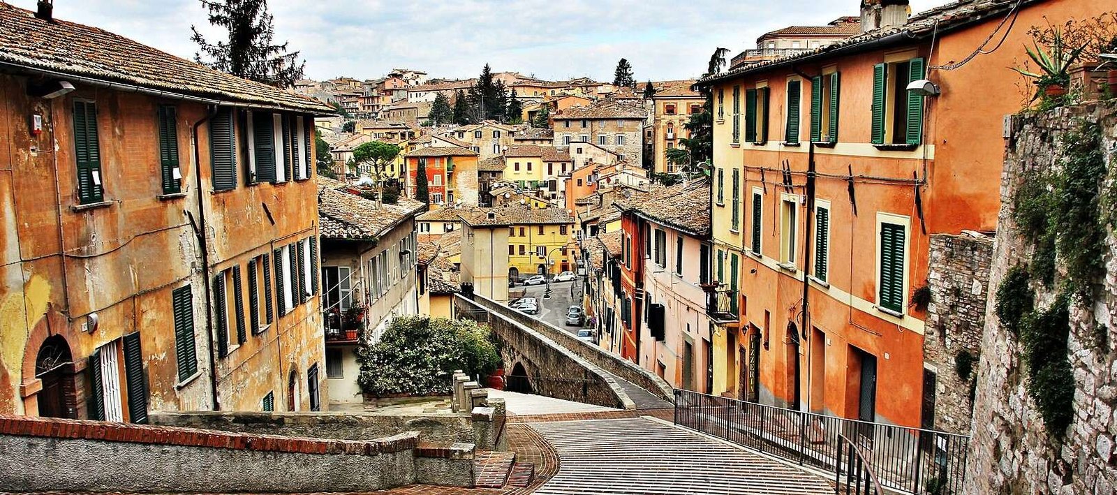
Perugia is a hilltop city with a compact medieval historic center and a more extensive modern area. Getting around may seem challenging at first, especially due to the slopes and different urban levels, but thanks to escalators, the minimetro, and well-integrated public transport, moving around Perugia is easier and more efficient than one might expect.
- Overview
- Getting There
- Airport +🔗
- Road, Train
- Getting Around on Foot
- Public Transport
- Getting Around by Car
- FAQ
Overview
Getting around Perugia requires a bit of initial orientation, especially due to its hilly layout and the clear distinction between the historic center and modern neighborhoods. The city develops on multiple levels, combining compact medieval areas with more recent, flat zones connected by integrated transport systems.
In the historic center, largely enclosed within Etruscan and medieval walls, walking is often the best option. Distances are short and allow easy access to main points of interest, although the presence of slopes and staircases makes it advisable to move at a relaxed pace.
To connect the center with outer areas, Perugia has an efficient network of public transport, consisting of urban buses and the Minimetrò, particularly useful for overcoming elevation differences and quickly reaching areas like Pian di Massiano, home to strategic parking lots.
A distinctive feature of mobility in Perugia is the system of escalators and urban elevators, which allows visitors to ascend from parking areas and stations to the heart of the historic city, significantly reducing effort and travel time.
The use of a private car is generally not recommended within the historic center, both because of narrow streets and the presence of a Limited Traffic Zone (ZTL). It is preferable to leave the car in exchange parking lots and continue with public transport or mechanized routes.
For a first visit, participating in a guided walking tour or following recommended routes can be helpful to understand the urban layout, navigate the city’s different levels, and acquire practical references for moving independently in the following days.
Finally, alternative mobility solutions such as bicycles and electric scooters are available, better suited to flat and peripheral areas. In the historic center, their use is limited due to slopes and uneven pavement.
Getting There
Perugia is well connected both nationally and internationally, thanks to a network of air, rail, and road links. Its central position in Umbria makes it easily reachable from many Italian cities, making it accessible for both tourism and business travel.
By Air
The Umbria International Airport – Perugia San Francesco d’Assisi (also called Perugia Sant’Egidio, see Info & Tips 🔗) serves national and international flights, especially low-cost and seasonal connections. From the airport, the city center can be reached by bus, taxi, rental car, or private transfer, with an average travel time of 20–30 minutes.
✅ To search or book a flight to/from Perugia, you can check Booking.com Flights.
By Train
Perugia Fontivegge is the main railway station in the city and is connected to Rome, Florence, and major Umbrian towns via regional and Intercity trains. The station is linked to the historic center via the Minimetrò, urban buses, and taxis, allowing fast access to central areas.
✅ You can check routes, schedules, prices, and buy tickets on Trainline.
By Car
Perugia is easily reachable by car via the E45 and SS75, connecting it with central and northern Italy. Those arriving by car should consider the Limited Traffic Zone (ZTL) in the historic center. It is recommended to use park-and-ride facilities at the city’s edges and continue with escalators, the Minimetrò, or public transport.
✅ For car rental, you can refer to Booking.com Cars.
By Bus
Perugia is connected to numerous Italian cities by long-distance buses, mainly arriving at Piazza Partigiani and the Fontivegge station. From there, it is easy to continue to the historic center and main neighborhoods via the urban bus network and the Minimetrò.
✅ You can check routes, schedules, and buy tickets on Trainline.
By Taxi or Private Transfer
Taxis and private transfer services allow direct and comfortable travel to Perugia from the airport, railway stations, or nearby cities. This is a practical solution for travelers with luggage or those who prefer to avoid changing transport modes.
Getting Around on Foot
Walking is one of the best ways to explore Perugia, especially within the historic center, where most attractions are concentrated in a relatively compact area.
Historic Center and Neighborhoods
The historic center of Perugia stretches along the hill ridge and is ideal to visit on foot: areas such as Corso Vannucci, Piazza IV Novembre, Fontana Maggiore, San Lorenzo Cathedral, and Rocca Paolina are easily reachable with short walks.
Distances and Travel Times
Distances in the historic center are generally short: from Piazza IV Novembre to Corso Vannucci takes just a few minutes on foot, while reaching Rocca Paolina or the main museums requires short but sometimes steep walks. Travel times depend more on elevation changes than on distance.
Elevation and Slopes
Perugia is characterized by ups and downs and staircases, typical of hill towns. This makes the visit scenic but requires some physical preparation. Proceeding slowly and alternating walking with mechanized sections is often the best solution.
Escalators and Assisted Paths
A major advantage for pedestrians is the efficient system of escalators and urban elevators, connecting parking areas and lower city zones to the historic center. These paths help overcome elevation changes, greatly reducing effort.
Road Surface and Comfort
The road surfaces in the historic center are mostly stone, cobblestones, and historic pavements. Comfortable walking shoes suitable for uneven and sloping surfaces are therefore recommended.
Traffic and Walkability
Vehicle traffic is limited in the historic center by the ZTL, making central areas particularly pleasant to explore on foot. It is still important to pay attention in access zones and along streets connecting to outer neighborhoods.
Urban Experience and Panoramas
Walking through Perugia means immersing yourself in an authentic atmosphere: medieval alleys, arches, panoramic terraces, and views over the Umbrian countryside make every walk a continuous discovery experience, making the city ideal to be explored step by step.
Public Transport
Perugia’s public transport allows travel between the historic center, residential neighborhoods, and outskirts, providing effective solutions despite the city’s hilly layout. The system mainly consists of urban buses, Minimetrò, and integrated services, designed to overcome elevation changes and reduce private car use.
Urban Buses
The urban bus network connects the historic center with outer neighborhoods, train stations, the airport, and main residential areas. The lines are numerous and widespread, although traffic can cause delays during peak hours. Buses are the most common means for daily city travel.
Minimetrò
The Perugia Minimetrò is one of the most practical and distinctive transport systems in the city. It connects Pian di Massiano, an area with large parking lots, to the historic center, with strategic intermediate stops. It is especially useful for overcoming elevation and quickly reaching the city center without traffic.
Escalators and Mechanized Paths
A distinctive feature of Perugia mobility is the system of escalators, elevators, and mechanized paths, connecting parking lots, stations, and lower areas with the historic center. These routes are integrated with buses and the Minimetrò, making pedestrian travel easier.
Taxi
Taxis are available at Perugia Fontivegge station, the airport, main squares, and central areas. They provide a convenient option for direct trips, especially for travelers with luggage or during evening hours when public transport is less frequent.
Tickets and Passes
The fare system includes single tickets, daily passes, and subscriptions valid on buses and the Minimetrò (see official site). Fares are integrated, allowing combined use of different transport modes. For updated information on schedules, lines, and prices, consult the Umbrian local public transport website (see official site).
When to Use Public Transport
Public transport is particularly useful for reaching the historic center from park-and-ride lots, moving between outer neighborhoods, and covering uphill distances. Within the historic center, walking is often the most practical option, optionally combined with escalators and assisted paths.
Getting Around by Car
Driving in Perugia can be useful for arrivals, departures, or reaching peripheral areas, but it requires attention due to the city’s hilly layout and the presence of a Limited Traffic Zone (ZTL) in the historic center.
Limited Traffic Zone (ZTL)
The historic center of Perugia is regulated by a ZTL active during specific hours, with access reserved for residents and authorized vehicles. Electronic gates control entry, and fines are frequent. Before entering, it is essential to check schedules, activation days, and available permits.
Pedestrian areas and historic center
Many areas of the historic center, particularly along Corso Vannucci and around Piazza IV Novembre and the Fontana Maggiore, are pedestrian or have heavily restricted access. In these cases, it is recommended to park outside the city walls and continue on foot or by public transport.
Traffic and road conditions
Traffic in Perugia is generally lower than in large cities, but it can increase during peak hours, events, fairs, or demonstrations. Access roads to the center often feature steep inclines, curves, and narrow lanes, making driving more challenging.
Parking areas
Perugia has on-street parking, paid lots, and numerous multi-story car parks, often connected to the historic center via escalators or the Minimetrò. Park-and-ride lots, such as Pian di Massiano, are a practical solution to leave your car and reach the center without stress.
🅿️ Pian di Massiano Parking
For those arriving in Perugia by car, the best option is the Pian di Massiano Car Park (see map 🔗). This large parking lot is located at the foot of the historic center, easily accessible from main roads, and ideal for stress-free parking.
The lot has 1200 parking spaces and is designed as a strategic access point to the city. From here, the Minimetrò departs (see Pian di Massiano terminal 🔗), allowing you to reach the historic center in minutes, avoiding traffic, ZTL, and steep inclines.
When to use a car
Driving is recommended mainly for reaching peripheral neighborhoods, accommodations outside the center, or excursions in the surrounding Umbrian area. To visit the historic center, it is usually more effective to combine external parking, mechanized paths, and walking.
✅ For more options and online bookings, you can check the ParkingMyCar service, which allows you to find parking throughout the city.
FAQ
What is the best way to get around Perugia?
The ideal solution is to park outside the center and move around on foot or using the MiniMetrò.
Is Perugia easy to explore?Yes, the historic center is compact and well connected by public transport systems.
📌 Learn more in the Overview section.
How can you reach Perugia?
Perugia can be reached by car, train, and bus from the main cities of Umbria and Central Italy.
Is the train station connected to the historic center?Yes, thanks to urban buses and the MiniMetrò.
📌 Learn more in the Getting There section.
What is the most convenient public transport in Perugia?
The MiniMetrò is the fastest and most practical way to reach the historic center.
Are urban buses useful for tourists?Yes, they cover neighborhoods well and complement the MiniMetrò service.
📌 Learn more in the Public Transport section.
Is it worth using a car in Perugia?
It is useful for arriving in the city, but not recommended in the historic center.
Where is the best place to park?The Pian di Massiano parking lot is the best and most convenient option.
📌 Learn more in the Getting Around by Car section.